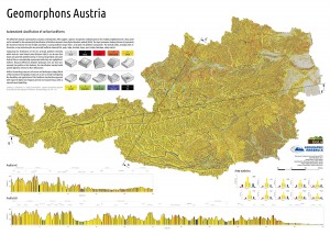
With the help of the GRASS GIS module r.geomorphon a map of principal landform units was calculated for the state territory of Austria. This highly automated classification approach will be applied for the study areas as well in order to compare locations of landslide scars with respective morphological forms. See Jasiewicz and Stepinsky (2013) for more details regarding r.geomorphon.
-
Archives
- July 2017
- June 2017
- April 2017
- November 2016
- June 2016
- April 2016
- February 2016
- December 2015
- November 2015
- June 2015
- March 2015
- January 2015
- November 2014
- October 2014
- September 2014
- July 2014
- June 2014
- May 2014
- March 2014
- February 2014
- January 2014
- November 2013
- October 2013
- September 2013
- August 2013
- July 2013
- June 2013
- May 2013
- April 2013
- March 2013
-
Meta